All tutorials
Adding the Planet Federal what3words plugin to QGIS
The QGIS plugin brings the functionality of the what3words API to the QGIS platform. You can use the plugin to convert from coordinates to 3 word addresses by adding a field to a Shapefile, as well as searching for 3 word addresses or inspecting the map to view the 3 word address for a location.
QGIS Minimum Supported Requirements: 3.0.0
QGIS Versions 1-3, Copyright (C) 2016-2020 build by Planet Federal
QGIS Version 4, Copyright (C) 2020-2022, updated by what3words Limited
Getting started with Dazi, GIS Technical Account Manager at what3words:
You can now download the What3words Tools directly from the QGIS Python Plugins Repository.
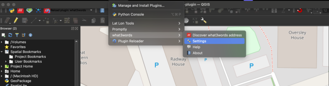
Open QGIS and click on Plugins > Manage and Install Plugins > type on the search bar for the what3words plugin and click on Install Plugin button.
Once enabled, you will see what3words under the Plugins tab, choose the Settings menu and then paste the API Key you have copied from your what3words account.
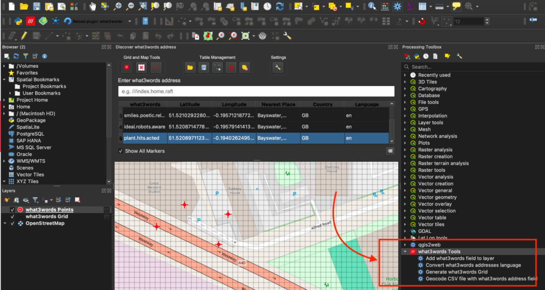
Here are all the available tools in the what3words QGIS plugin:
Grid & Map Tools:
1. Click on the map to capture and display the what3words address for that location.
2. Toggle the what3words grid overlay to visualise the 3m x 3m square system (click again to disable).
3. Open the what3words map site directly from the plugin for external address lookup.
Table Management Tools:
4. Import what3words addresses or coordinates from CSV.
5. Export the address table to a CSV for external use.
6. Create a temporary feature layer from stored what3words addresses.
7. Delete the selected what3words address from the address table.
8. Delete all the what3words addresses from the address table.
Settings:
9. Access plugin settings from the toolbar:
- Enter your API key;
- Set your preferred language for addresses;
- Configure a custom or enterprise API endpoint (if needed).
Marker Management:
10. Toggle visibility of map markers associated with what3words addresses.
11. Clear all map markers from the basemap as required.
Address Table:
12. When clicking on the map, addresses appear in the table below. You can:
- Copy cell content
- Zoom to feature
- Flash or highlight the feature
- Select a feature by clicking on its record
AutoSuggest Search:
13. Start typing a what3words address in the AutoSuggest input field to receive up to 3 matching suggestions instantly.

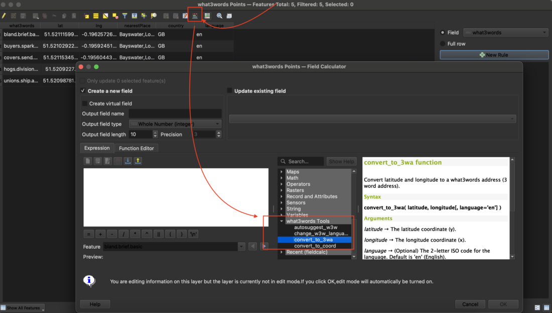
⚖️ Field Calculator Integration
The what3words plugin lets you perform the field calculations directly within the attribute table of any vector layer
Within attribute tables, you can:
- Convert between coordinates and what3words;
- Change the language of existing what3words addresses;
- Use AutoSuggest when editing fields to help complete valid what3words addresses.
To get started:
- Open the attribute table of any vector layer;
- Click the
Field Calculator(🧮) icon in the toolbar.
⚙️ Processing Toolbox Integration
Use the what3words tools directly in your geoprocessing workflows via the QGIS Processing Toolbox:
- Generate a what3words grid for any selected area
- Convert the language of what3words address attributes in vector features
- Add a what3words address field to a layer using coordinate geometry
- Geocode a CSV file containing what3words addresses into point layers for spatial analysis
To get started, open the Processing Toolbox in QGIS by navigating to Processing > Toolbox from the top menu. Then, expand the what3words section to access the available tools.
If you encounter errors or issues related to convert-to-coordinate, convert-to-3wa and grid-section requests while using the Free plan, please check the network panel for the following error message Error 402 payment required and its response, indicating the need to upgrade to a higher plan:
{
    "error": {
        "code": "QuotaExceeded",
        "message": "Quota exceeded or API plan does not have access to this feature. Please change your plan at https://accounts.what3words.com/select-plan, or contact support@what3words.com"
    }
}
For more information, visit our API plans page. If you need further assistance, contact support@what3words.com.
Use the QGIS What3words Tools to convert coordinates in any coordinate system to what3words. If you have data in a different coordinate system than WGS84, our What3words Tools handles the transformation of the original coordinate system to WGS84, as it is expected by what3words.
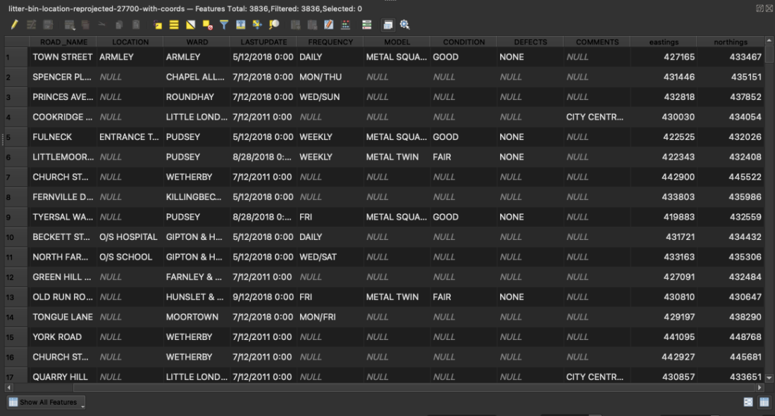
In this example, we will show how a CSV file with coordinates (Easting and Northing) in EPSG:27700 – OSGB 1936 / British National Grid can be imported into QGIS and how our What3words Tools can handle the transformation from this coordinate system to WGS84 while adding the what3words address to this file.
Note: make sure the Easting and Northing are integer numbers.
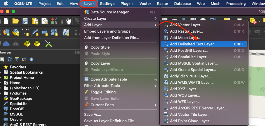
To import this CSV to QGIS we need to go to Layer > Add Layer > Add Delimited Text Layer.
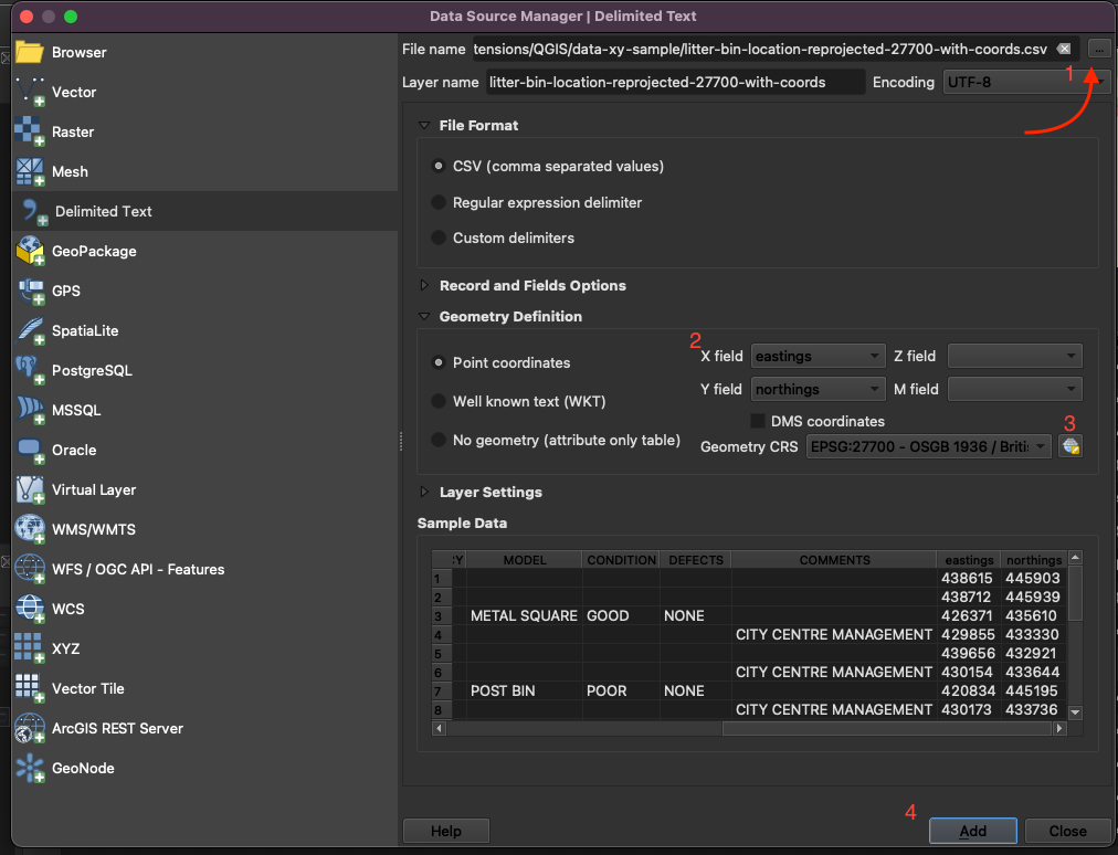
- Then Import the File name from the original source by clicking on the 3 dots button.
- Choose the Geometry Definition, Point coordinates and assign your x field to your easting and the y field to your northing (since our example it is using the British National Grid, otherwise you should choose the longitude and latitude instead);
- Then assign the Geometry CRS to your CSV file, in our case the EPSG: 27700, it might ask you to choose some transformation, please use the most appropriate for your project.
- Then you are ready to click the Add button to import this file onto your QGIS project. You will see point features being plotted on the map.
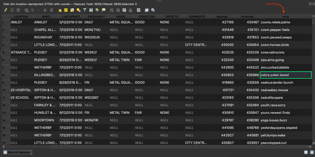
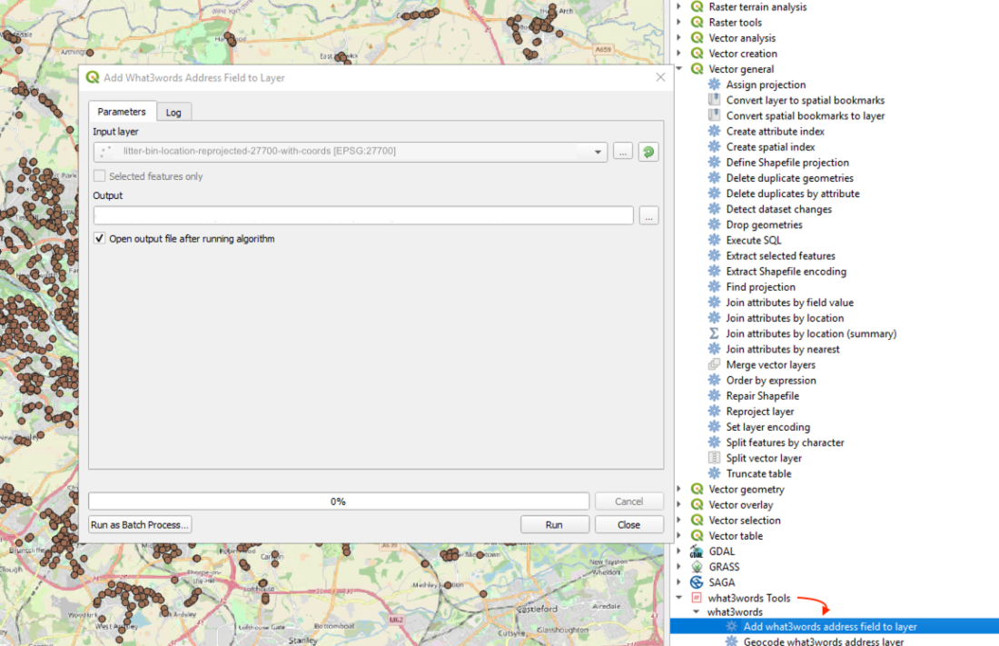
Now we want to add what3words addresses to these point features. After enabling the what3words tools plugin on your QGIS project, open the Processing Toolbox, the what3words tools plugin would be visible at the bottom. Click on the tool Add what3words address field to layer. Choose your input layer, and output otherwise QGIS will save it as a temporary file, then click the button Run.
After the tool run successfully, if you open the attribute table of your point feature you will see a new column called w3w at the end of this table.